 القاهرة - شيراتون المطار - النزهة - رقم بريدى 4471347

 info@geopatra.org

Our projects
A clear imprint in infrastructure and smart cities
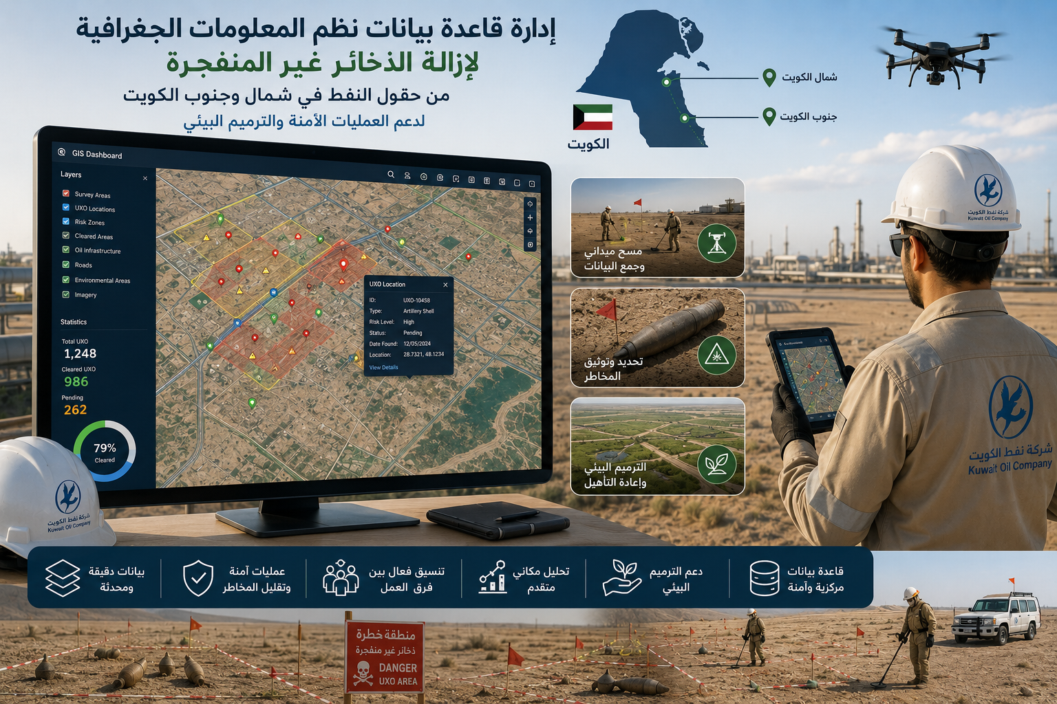
UNDP Kuwait - Unexploded Ordnance Removal
Managing GIS databases for unexploded ordnance removal projects. Supporting spatial analysis and survey operations across oil fields in northern and southern Kuwait. Accurately documenting hazardous zones and unexploded ordnance locations. Providing updated geospatial data to support safe field operations. Helping reduce risks for operational teams and o...
-

Location: Kuwait
-

Site space: 2000 meters
-

Duration: 1 year
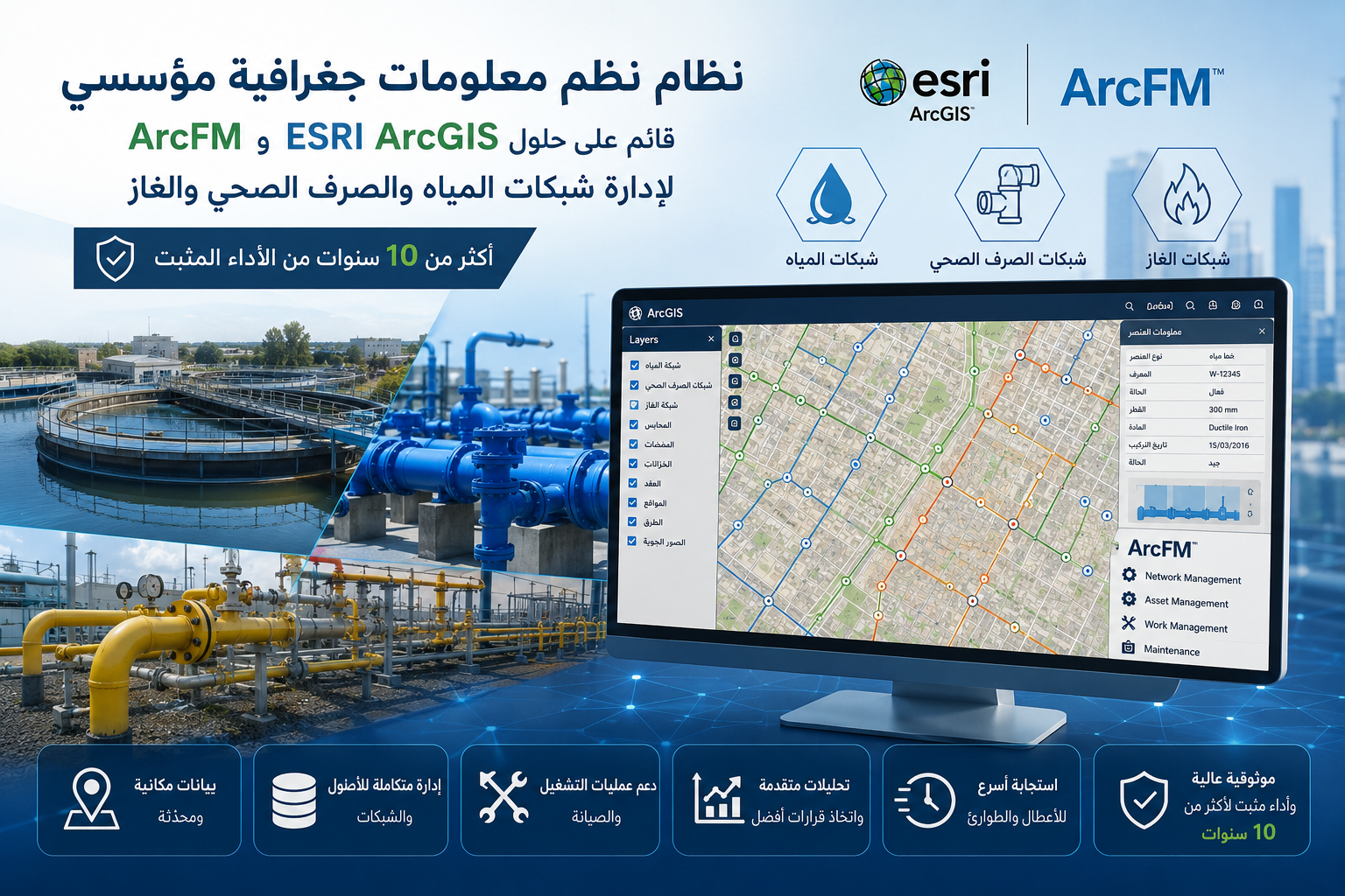
U-FM - Utility & Facility Management System
Developing an enterprise GIS system for managing critical utility networks. Utilizing ESRI ArcGIS and ArcFM solutions for network management and analysis. Managing water, wastewater, and gas networks through a unified platform. Enhancing infrastructure and asset tracking with high accuracy. Supporting operation and maintenance teams with integrated spati...
-
Location: U-FM
-
Site space: 2000 meters
-
Duration: 1 year
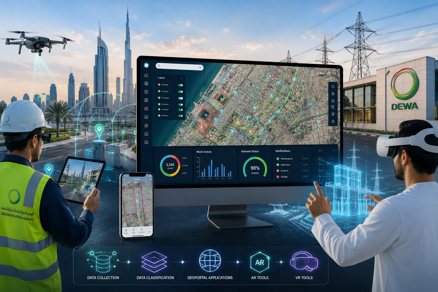
DEWA Dubai - GIS Project with AR/VR Integration
Developing custom solutions for field data collection and management. Classifying and organizing geospatial data within enterprise systems. Creating interactive geoportal applications for data visualization and analysis. Integrating Augmented Reality (AR) technologies to enhance spatial data experiences. Utilizing Virtual Reality (VR) tools to simulate i...
-
Location: DEWA Dubai
-
Site space: 2000 meters
-
Duration: 5 months

EEHC Egypt - GIS & Advanced Distribution Management System (Cairo & Alexandria)
Leading technical coordination for the digital transformation of electricity distribution networks. Converting traditional linear diagrams into structured digital data. Building enterprise geodatabases to manage electrical network assets. Linking electricity network data with real-world geographic locations. Developing geoportal platforms to visualize an...
-
Location: EEHC Egypt
-
Site space: 2000 meters
-
Duration: 5 months
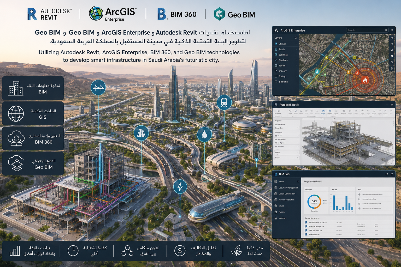
NEOM Project - Nebian Main Water Transmission Line
Utilizing Autodesk Revit for accurate building and infrastructure modeling. Using ArcGIS Enterprise to manage and analyze geographic and spatial data. Applying BIM 360 to enhance collaboration between design, construction, and management teams. Integrating Geo BIM to connect building models with real-world geographic data. Developing smart infrastructure...
-
Location: Future City in Saudi Arabia
-
Site space: 2000 meters
-
Duration: 1 year
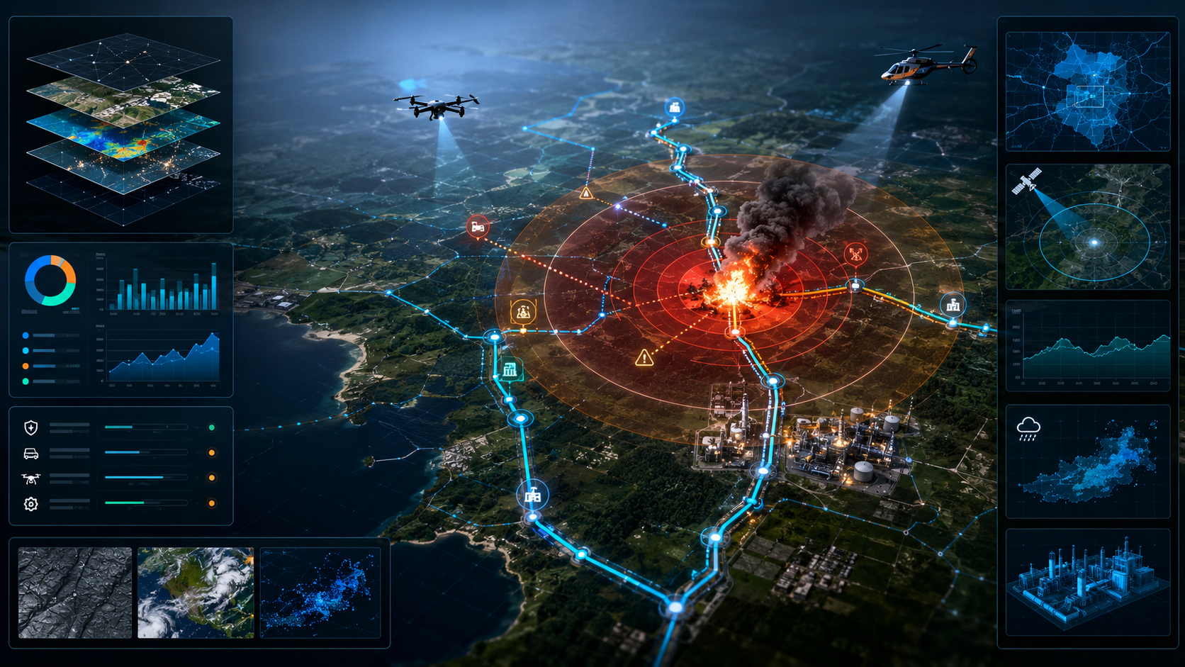
ePipe - Pipeline Emergency Response System
A searchable, interactive dynamic map. Integrates data from multiple sources into one platform. Helps emergency officials assess the impact of pipeline explosions. Clearly displays affected areas and potential risks. Supports response teams in making faster and more accurate decisions. Identifies the most effective response and field intervent...
-
Location: Future City in Saudi Arabia
-
Site space: 2000 meters
-
Duration: 5 months
Developing the digital infrastructure of the new city of El Alamein
Our company has worked to design and implement an integrated GIS Maps system for the new city of El Alamein, allowing facilities networks (water, electricity, sanitation) smartly, with linking to BIM technologies and digital twins to increase operational efficiency and reduce malfunctions.
-
Location: The New City of El Alamein - Egypt
-
Site space: 2000 meters
-
Duration: 5 months

Developing the digital infrastructure of the new city of El Alamein2
Our company has worked to design and implement an integrated GIS Maps system for the new city of El Alamein, allowing facilities networks (water, electricity, sanitation) smartly, with linking to BIM technologies and digital twins to increase operational efficiency and reduce malfunctions.
-
Location: The New City of El Alamein - Egypt
-
Site space: 2000 meters
-
Duration: 5 months